Showing posts with label Land Surveying. Show all posts

Friday, June 1, 2012

America's Most Wanted Goes After Surveyor Who Murdered Florida Woman

***  UPDATE  ***
GONZALEZ ARRESTED IN MEXICO!

"The Lee County Sheriff’s Office has announced it will hold a news conference today at 1:30 p.m. to announce a major development in the Tia Poklemba case.
Sheriff Mike Scott, detectives who worked the case and Poklemba’s mother and sister will be in attendance.
Poklemba's body was found bruised and bloodied on the side of a San Carlos Park road on Aug. 8, 2008. She later died.
Luis Gonzalez, then 25, was charged with manslaughter with a weapon and fleeing the scene of a fatal accident. He was never located and it was believed he fled to Mexico."  read more HERE


**UPDATE - SEE BELOW**

Luis Gonzalez
Wanted for Murder
Gonzalez, who was working as a land surveying technician, repeatedly ran over and murdered 25-year-old Tia Poklemba of the Fort Meyers area of Florida on August 8, 2008.

Tia (right) and her mother Deb (left)

Help find justice for Tia's family and friends. 

The land surveying community is small and I think we can help bring Gonzalez to justice.  Verify that the laborer you have on your survey crew is NOT Luis Gonzalez!

To learn more about the case, go to AMW.com.

If you see Luis Gonzalez or know where he might be, call 911! 

**UPDATE - The AMW story has also been posted on the California Land Surveyor's Association website.  Anyone with information is urged to contact your local police.  Call 911 if you see Luis Gonzalez or know where he is.**

Monday, October 3, 2011

Irvine-based Engineering Firm Joins Giant Michael Baker Corporation

Here's an email from RBF:

As our valued client and colleague, we would like to take this opportunity to share with you some exciting news about our company that will bring added value to all of the agencies, companies and organizations that we serve. Today, RBF Consulting has the honor and pleasure of joining one of the most prestigious, well-respected firms leading our industry, Michael Baker Corporation.
Many factors influenced our decision-making process, but the highest and most important consideration has been our clients and our ability to best serve you. We know that as RBF Consulting, a Company of Michael Baker Corporation, we will be able to offer you more in the way of experts, services, and overall capacity while also maintaining our existing quality of service, local experts, projects and personal relationships.

As a result of this combining of capabilities, we have gained the depth and expertise of Baker, with expanded services in architecture, aviation, defense, environmental, facilities, geospatial, homeland security, municipal, civil, pipelines/utilities, rail, transit, transportation and water.   RBF Consulting's 17 offices and over 500 team members will bring Baker to over 3200 people with 107 offices to serve our clients locally, regionally, nationally and internationally. We are truly excited about these added capabilities and services, as well as the highly complementary geographic match of our locations. We would like to share a few key points with you regarding the advantages and purpose of this combining of capabilities.

RBF is prominent in the Southwest while Baker maintains a strong presence in the remainder of the U.S. The combination of the two firms provides an effective West Coast platform for Baker's nationally recognized services and creates a truly national engineering consulting and professional services firm. Based on 2010 financial results, the combination of Baker and RBF will place the combined firm in the range of 26th on Engineering News Record's top 500 Design Firms list. Baker dramatically expands RBF's geographical reach and increases potential market share for its services while being supported by a larger organizational structure. RBF's Water Resources experience and expertise will provide the platform for Baker to build a national water and wastewater practice.

RBF provides Baker with access to a new and diversified client base, including the private sector, which will help Baker to meet its objective of a more balanced public/private business mix. It also creates the critical mass to be even more competitive on Transportation, Civil, Environmental and Defense projects on the West Coast, while integrating further capabilities in Planning and Urban Design.

A combined Baker and RBF places emphasis on and strongly supports the internal and external sustainability initiatives of both firms. Baker and RBF share aligned core values, business philosophies, mission statements and vision for the future.

Together, as we continue our valuable relationship with you, we are excited about the future. As we move forward, we eagerly look forward to bringing you value by delivering innovative and sustainable solutions for infrastructure, development and the environment.

Sincerely,

Robert S. Kallenbaugh, P.E.                     James E. McDonald, P.E.
Co-CEO                                                 Co-CEO
RBF Consulting                                        RBF Consulting

Friday, April 8, 2011

Taken for a ride?

Ever get that feeling you’ve been taken for a ride?  You know, like when the mechanic tells you a belt in the car is about to fail or your brakes are shot?  Or how about when the handyman asks for cash up front to buy the materials for your new repair project? 

Whatever the circumstances, the feeling usually occurs as the culprit’s tail lights fade into the distance or you pull out of the mechanic's service station. 

Some scammers even provide a half-hearted “professional” service that, to the untrained eye, appear to be just what was asked for. Unfortunately, this almost always happens when you can least afford it. 

Bait and switch schemes involving fraudulent and unscrupulous contractors are too common.  They happen when a contractor is being paid to use one product and switches it out with a cheaper product without approval from the owner, engineer, or architect.  It could be a brand of windows or pipes; whatever will go unnoticed.  Fortunately for the consumer, building inspectors are there to catch shoddy work or incorrect materials before the project moves too far too fast.

But what can you do if you don’t have a public official there to guard against you being taken for a ride?  What can you do to protect you, your property, your wallet, and your reputation?

Recently, an architect was overheard saying that he “knew the surveyor was a crook because he was only on the job site for 4 hours but he billed $800!” In this real-life example, the architect was right that the surveyor was a crook and that the amount billed was not in proportion to professional services rendered by a duly licensed land surveyor. The architect got exactly what he paid for. 

Professional services do not come without a price.  If you went to a doctor who spent 4 hours repairing your body or consulting you, would an $800 bill be justified?  We might like the insurance to cover it, but an $800 bill would probably be cheap. 

So what do professional land surveying services cost and why?  Like many things, professional land surveying services cost what the market will bear, sometimes more, and sometimes less. 

Some professional land surveyors offer services in a menu fashion.  For example, they offer all “lot surveys are $500” or all “deed preparations $200”.  The problem with offering services like this is that some people will cut corners to achieve their price point and make a profit, despite the harm or injury they may cause to consumers. 

As a licensed professional land surveyor, I can safely say that I have never encountered a situation where I would feel comfortable charging $500 for a "lot survey".  Let’s consider the following:

Any "lot survey" (assumed to mean a boundary survey) in California will require research at least at three government offices: the county recorder, county surveyor, and city hall.  You may also need, and I always recommend, obtaining a title report.  The research, less the title report will easily eat up one 8-hour day.

Next, the licensed professional land surveyor must review the findings of his or her research.  They must begin to reconstruct on paper how the property was created.  This reconstruction is somewhat similar to the way an architect might create a model but without any creativity.  The research materials are evidence which are all weighed and considered. 

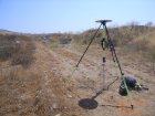
Now the licensed professional land surveyor (or their technician) visits the site and begins the field survey.  This can last hours, days, weeks, or longer.  This phase is specifically to recover field evidence.  The evidence may include physical improvements such as fences, wall, buildings, or other features.  It will also include the search and recovery of survey monumentation.  All of the evidence is located and referenced to a singular point of origin, or datum, so that the measurements between the evidence are relevant to one another.  Another type of evidence collected is parol.  Speaking with persons who have no interest in the rights of the land being surveyed together with special knowledge of the land’s boundaries or rights thereto are sworn in, interviewed, and their oath taken.  The field survey can last hours, days, or, in some cases, even years. 

Once the evidence is collected in the field, it is weighed together with the parol and research evidence.  It may be held up and compared with certain case law.  Ultimately, the licensed professional land surveyor opines a conclusion from the evidence and reestablishes the most likely location of the land boundary.  This may take a few hours or many days to conclude depending on the breadth, depth, and magnitude of the property and the research materials.

If you wanted your boundary marked with survey monuments, the licensed professional land surveyor (or their technician) will return to the property and layout the locations of the property corners, set monuments that represent the property corners, and document any irregularities observed since their last visit to the site.  Setting monuments for small lots (less than an acre) in a suburban or urban environment usually takes a few hours.  Rural parcels may take much longer, depending on topography, neighbors, weather, etc.

The location of the boundary lines and any monuments set are documented by the preparation of a map, usually a Record of Survey.  A Record of Survey is a type of survey map prepared by a licensed professional land surveyor and submitted to the County Surveyor’s Office for review (sometimes for a fee) who will then file it with the County Recorder’s Office. 

As you can imagine, a “small lot survey” may take a week to begin and conclude.  Is that worth $500 or $800?  Not to the professional.

Considering the experience, education, specialized hardware and software that most licensed professional land surveyors have, a survey of a smaller magnitude such as outlined above should probably cost a minimum of $3,000.  Even $5,000 would not be an unreasonable fee considering the aforementioned time involved.   

Back to our disgruntled architect.  Although he felt like he was being ripped of because the surveyor was there for 4 hours but billed $800, the architect was not overcharged and ripped off.  In fact, the architect was certain the surveyor had done everything that any other duly licensed professional land surveyor would have done.  The reality is that the surveyor did not conduct proper research, did not weigh all of the evidence, and did not file a legally required map, the totality of which reveals that the surveyor was practicing below the standard of care required by law and expected by consumers.  Had the surveyor practiced accordingly, he would have had to bill the architect about $4,000.  The surveyor in question is in the process of having their license revoked.

Here are some things you can do if you need to employ the professional services of a civil engineer or land surveyor and protect yourself from being taken for a ride.

First, get references and CALL them.  Don’t email or send a letter because respondents, concerned about potential litigation for slanderous statements may wish to speak openly “off the record”. 

Second, contact your state’s board of registration that regulates engineers and land surveyors. In California, the Board for Professional Engineers, Land Surveyors, and Geologists is the authority to contact (http://www.pels.ca.gov/ or 1-866-780-5370).  Find out if they have any “actions” or complaints pending or if their license has ever been disciplined. 

Third, ALL licensed professional engineers and land surveyors are required to have a contract (B&PC 8759).  Contracts must include the following:
  • A description of the services to be provided to the client
  • A description of any basis of compensation applicable to the contract, and the method of payment agreed upon by the parties.
  • The name, address, and license or certificate number of the licensed land surveyor or registered civil engineer, and the name and address of the client.
  • A description of the procedure that the licensed land surveyor or registered civil engineer and the client will use to accommodate additional services.
  • A description of the procedure to be used by any party to terminate the contract.

In the case of our architect, B&PC 8759 specifically states that no contract is necessary if the licensed professional engineer of land surveyor provides services to any of the following parties:
  • A land surveyor licensed under this chapter.
  • An architect licensed under Chapter 3 (commencing with Section 5500).
  • A contractor licensed under Chapter 9 (commencing with Section 7000).
  • A geologist or a geophysicist licensed under Chapter 12.5 (commencing with Section 7800).
  • A manufacturing, mining, public utility, research and development, or other industrial corporation, if the services are provided in connection with or incidental to the products, systems, or services of that corporation or its affiliates.
  • A public agency.

Clearly, the law expects certain professionals, such as architects, to understand what types of services are being provided and their associated costs when they consult with a licensed professional engineer or land surveyor. 

It is assumed that consumers by and large do not have the technical understanding of these professions and so contracts must be executed. 

In California, consumers can contact the California Land Surveyor’s Association (CLSA) at http://www.californiasurveyors.org/index.asp or (707) 578-6016.  The CLSA represents all land surveyors, whether they are employees or proprietors, whether in the public or private sector as a professional society and is NOT a union or bargaining unit. 

Consumers are also encouraged to go to http://clsaforum.californiasurveyors.org/index.php and ask questions on the message board.  Most of the commentators are licensed professional land surveyors who are more than happy to offer up advice and answer questions.  You don’t have to be in California to ask questions but you should mention that up front so you get a thorough response. 

Wednesday, January 12, 2011

Wednesday, April 21, 2010

Subdivision Map Act Seminar Update


WHAT IS COVERED?

This seminar provides guidelines for effective use of the Subdivision Map Act. The instructors will discuss the responsibilities and powers of local agencies under the Act, as well as particular issues regarding when the Act applies.

Seminar highlights:
•Discussion of Legislative and Judicial changes in 2009
•Relationship of Map Act to other planning, zoning and development laws, and to CEQA
•When the Map Act applies (and when not)
•What kind of Map (Tentative/Final or Parcel Map) to use
•Certificates of Compliance
•Lot Line Adjustments
•Exemptions and exceptions under the Map Act
•Life of Tentative Map
•Vested Rights (including Vesting Maps, Development Agreements and Common Law Vesting)
•Exactions/Dedications/Fees
•Creative mapping approaches


WHO SHOULD ATTEND?
This seminar is designed for planners, surveyors, engineers, developers, builders, attorneys, project managers, architects, planning commissioners, council and board members, property managers, public works and utilities directors, zoning board members, and all others involved with the land use process.


This course qualifies for 6.0 hours of California MCLE credit.


Monday, March 22, 2010

Hundreds Gather for Trigonometry Competition at Santiago Canyon College


March 20, 2010
Trig Star 2010 attracted hundreds of high school students and their parents from a dozen Orange County area schools. Also in attendance were Santiago Canyon College students. What could possibly compel these students to wake up early on a Saturday morning to take a trigonometry exam? How about $500 and scholarship opportunities! Winners walked away with $500, $300, and $200 for first, second and third place respectively. The college students took the same exam but were competing for their own prizes in the same amount of money. Exams were scored immediately following the exam by a dozen volunteer proctors. The event closed out with the announcement of the winners of Trig Star and an exciting competition known as the Surveyor's Challenge. The winners of the Surveyor's Challenge walked away with $50, $30, and $20 awards for measuring angles and distances and then applying trigonometric principles to their measurements to determine the size, shape, and area of certain features on campus. A grand prize was also handed out. The Garmin eTrex Legend H, worth about $150, went to the overall Surveyor's Challenge winner, Vallentino Leanarduzzi, a Santiago Canyon College Survey/Mapping student.
Numerous industry leaders were on hand to recruit and educate visitors about land surveying and mapping.  The primary sponsor, the Orange County Chapter of the California Land Surveyor's Association (OC-CLSA), donated nearly $6,000 to make the event a success.  Other sponsors included the Port of Long Beach, California State University at Fresno's Geomatics Engineering, Psomas, Johnson-Frank, RBF, the County of Orange's Geomatics/LIS Division, Professional Engineers in California Government (PECG), Santiago Canyon College's Career Education, and me. 


Tuesday, March 9, 2010

Rancho Santiago Community College District Press Release


Santiago Canyon College Hosts Fifth Annual Trig Star


Orange County Event Jump Starts National Surveyors Week – March 21-27

Orange—While many people may know that surveyors are responsible for making accurate measurements to establish official land, space and water boundaries, they may not know that surveying is an in-demand profession. In California, it is expected that by 2016 the occupation will sustain a 13.6 percent spike in jobs with a median hourly salary of more than $36. To provide insights into this growing occupation, high school, community college students and their parents are invited to attend Trig Star, a free, entertaining day of activities that introduces young people to challenging, lucrative careers in land surveying and mapping sciences.

The event will be held on Saturday, March 20, from 9:30 a.m. to 1:00 p.m. at Santiago Canyon College in Orange. Students can win cash and prizes in a trigonometry competition and the Land Surveyor’s Challenge. The event includes free parking, and informational exhibits. The free registration deadline is Friday, March 19. After that date, a $5 fee will be charged.

The day includes three components. First, students will vie for three top cash prizes in the trigonometry competition. The top high school contenders will advance to the state competition and the very best at the state level go on to the national competition. Second, participants will try out their surveying skills in the Land Surveyor’s Challenge where they use handmade devices to measure and calculate the height, distance, and angles between pre-determined points on campus. Third, the young people and their parents will learn more about the industry through exhibits featuring equipment and information from the area’s leading mapping sciences and land surveying firms.

“Due to several factors, including the poor economy, our profession has lost some very talented people and we need to prepare our workforce for the coming onslaught of infrastructure work that California desperately needs,” said Gregory C. Sebourn, PLS, California Land Surveyors Association-Orange County (CLSA-OC); Trig Star Committee Chair; and SCC instructor. “Trig Star will help raise students’ and parents’ awareness about the profession of land surveying and the educational opportunities that exist at Santiago Canyon College and Cal State Fresno.”

This year’s Trig Star event is scheduled to coincide with the beginning of National Surveyors Week. Trig Star 2009 attracted more than 250 students from Orange County high schools and community colleges. This year’s prizes include cash awards of $500, $300, and $200 for first, second and third place in the trigonometry competition. High school and college students will compete in separate categories for prizes. Winners in the Land Surveyors Challenge will receive gift certificates, and one grand prize will be awarded.

Land development throughout California, the $42.7 billion in infrastructure improvements passed by voters in November 2006, and the retirement of many of today’s surveyors will create a huge demand for entry-level employees. Surveyors and mapping technicians can work in government, engineering, architecture, construction, real estate, transportation, utility companies, and other industries.

Santiago Canyon College offers both an associate degree and a five-course certificate that qualify students for entry-level employment in survey/mapping sciences. With only two programs offered among Southern California community colleges, student enrollment has grown by over 450 percent in the past several years.

Trig Star is sponsored by the Orange County Chapter of the California Land Surveyors Association (CLSA) and is part of a nationwide competition of the National Society of Professional Surveyors. The event is facilitated by Vital Link of Orange County. Additional sponsors include Psomas, Johnson-Frank & Associates, Inc., RBF Consulting, the Port of Long Beach, the County of Orange, Cal State Fresno Geomatics Engineering, and the Professional Engineers in California Government.

For more information or to register for Trig Star, please contact Vital Link Orange County at (949) 646-2520 or e-mail kathy@vitallinkoc.org.

Santiago Canyon College is a public community college, part of Rancho Santiago Community College District. It serves the residents of Anaheim Hills, Orange and Villa Park. The college provides education for academic transfer and careers, courses for personal and professional development, and customized training for business and industry.

Friday, March 5, 2010

Trig Star March 20, 2010 At Santiago Canyon College


Sponsored by the California Land Surveyor's Association, Santiago Canyon College, and the National Society of Professional Land Surveyors


High School Math Skill Award

The TrigStar Program Contest is an annual high school mathematics competition sponsored by the National Society of Professional Surveyors based on the practical application of Trigonometry. The program recognizes the best students from high schools throughout the nation.


The purpose of the TrigStar Program:
To promote the study of trigonometry in high school and to promote excellence in the mastery of trigonometry by honoring the individual student who has demonstrated superior skill among classmates at the High School level.


To acquaint the high school trigonometry students with the use and practical application of trigonometry in the surveying profession.


To build an awareness of surveying as a profession among the mathematically-skilled high school students, career guidance counselors and high school math teachers.


Trigstar Contest Levels:
Level 1 is given at local high schools. There is one winner from each participating high school.
Level 2 is the national test. The state winner from each participating state is eligible to compete for the National Trig-Star title
Local Awards
Local and State awards are provided by the local chapter or sponsors.


National Awards

National awards provided by the National Society of Professional Surveyors Richard E. Lomax
National Trig-Star and Teaching Excellence Awards


First place winner - $2,000.00 award
Second place winner - $1,000.00 award
Third place winner - $500.00 award

Click here for sample tests!

Saturday, February 13, 2010

Two TV Shows With Land Surveyors


http://www.wtsp.com/news/columnist/story.aspx?storyid=108025&catid=79

“Tampa, FL - Robert Sullivan, a land surveyor, was one of more than a thousand people who showed up at the St. Pete Times Forum at 5 a.m. for a chance at getting in the hot seat on Who Wants To be a Millionaire?.
Before he even filled out a form, he knows where the money will go. "I have two five year olds. Anything that I can do to secure their education and their futures is where the money will go." His slow work schedule allowed him to take off time to audition.
Producers say they have seen more and more people affected by the economy who are auditioning. "It's not people that are desperate, that their house is about to go on foreclosure, but it's people that are afraid they are going to get there," said Co-executive Producer Rich Sirop.”


Season 6: Episode 01: Hangman
"Don’s team is charged with running VIP security for a big political rally featuring high profile activist Benjamin Polk. While scouting out the venue in preparation for the event, Don and his team come under heavy fire and receive a message to stay away from Polk during the rally. This overt attempt to scare Polk and the FBI away doesn’t work, and Polk insists on keeping his speaking engagement at the gathering. The FBI then digs in to try and discover who is making the threat, and discover that it’s a man who’d lost his son during a violent riot orchestrated by Polk to gain political street credit in order to further his own career. Furious that his son had been blatantly used as a pawn, the man, Shepard Crater, had come to LA to exact revenge. On the day of the rally Crater sets off a sequence of events to force Polk back to his hotel, where Crater is set to ambush and kill him. Charlie deduces the plot just in time, and David and Colby move in and take Crater down before he can kill Polk. However, after learning the whole story from Crater before they take him down, Colby and David meet with a political journalist and blow the whistle on Polk’s tactics, effectively ruining his political career."

This excerpt doesn’t mention it but in the middle of the episode a character pulls out an old Geodimeter total station and places it on an aluminum tripod to collect supplemental data for a 3D map. It wasn’t a long scene nor was it perfect but it was cool!

Monday, January 11, 2010

"Professional" Only In Flori-DUH!

An article appeared in the January 2010 issue of Professional Surveyor wherein the author, David W. Gibson, applies a Florida Supreme Court ruling to ALL professions as a status qualifier.  In his article Gibson asserts that the Florida Supreme Court defined a profession as “…we hold that a ‘profession’ is any vocation requiring at a minimum a four-year college degree before licensing is possible in Florida.  There can be no equivalency exception.”  Gibson goes on to quote the Court saying because Florida surveyors were not at some point required to have a four-year degree that “…land surveyors thus are not professionals for purposes of the statute of limitations.”  There are a few key words I need to point out. 

Monday, December 21, 2009

Monumental Job


I have the honor of placing this brass monument at the intersection of Lakeview Avenue at Santa Ana Canyon Road and another just like it to the east a hundred feet or so.  They will be set down about 1 foot inside of a protective well for surveyors to use for generations to come.  The "PLS 8395" is my California Land Surveyor's license number.  Proudly my license number and employing firm, Johnson-Frank & Associates, are stamped into the brass so that future surveyors can identify the brass cap and differentiate it from other types of monuments. 

The hard part will be managing traffic.  If I close one lane for more than about 10 minutes, the entire eastbound Riverside Freeway (SR91) will begin to back up as well as the northbound Costa Mesa Freeway (SR55) even though we are working on surface streets. 

Monday, November 9, 2009

To The Next Level


In January 2009, I wrote an article for Professional Surveyor Magazine that showcases what works and doesn't work when it comes to land surveying education.  Take a minute and check it out here!


Wednesday, October 28, 2009

The Trouble With Public Awareness

(This post was originally directed at the Land Surveying community.) 
I’m not a professional teacher, rather a professional who teaches. It is a part-time job and one that I find very rewarding despite the extraordinary low pay and the demanding hours. For those that haven’t taught as an adjunct professor (a fancy way of saying part-time college teacher), the first semester is the hardest. After a few semesters of getting your handouts, outlines, exams, and instruction dialed in, you can almost go on autopilot. Teaching gets a little easier and a lot more fun!


That’s all well and good at the college level, but what happens in primary education, locally known as K-12? It seems that each year brings with it a new way to teach those old subjects which had been taught the same for years. Not being a professional teacher and not attending those conferences that your child’s teacher attends during the summer, I cannot comment on the reasoning behind the constant changes in the delivery of instruction. Whatever the reasoning, the results are damaging.


Each semester the number of students who lack math skills seams to increase. I shouldn’t be surprised since I am (was) one of those who skated by, under the radar. My high school had numerous math classes for those who didn’t appear to be academically skilled, such as “business math” (not what it sounds like) or “personal finances”. These classes allowed for us non-intellect-types to still graduate even though we were clearly mathematically disadvantaged. The majority of students entering my classroom are quite capable of learning algebra, trigonometry, and geometry yet few have ever studied math beyond pre-algebra. Why? Is it possible that these highly skilled and educated professional teachers have failed in someway? I am not certain of the cause, but I am certain of the effect.


The first two weeks of our introductory course is spent assessing students math skills or lack thereof. The following weeks are spent trying to get the students up to speed with basic trigonometry. This tends to cause all surveying instruction to be behind schedule for the rest of the semester. It also forces survey instructors to be substitute math and trig teachers which isn’t fair to the students or teachers.


Recently, I learned that surveying is not alone in this anomaly. As it turns out, many other community colleges (and whisperings from university faculty as well) are dealing with the same situation. One solution which I think is really a work-around for the real problem, is to offer a “trades math” or “mathematics for the trades” class. The courses tend to be geared towards carpenters, plumbers, and machinists, but they are also applicable to land surveying. I suppose if one wanted to know just the bare minimum to get by on exams and as a field surveyor, this might be good enough. However, for those who have the vision of becoming professional land surveyors, this may be just the beginning.


That begs the question, what can we do as a profession to help our cause of recruiting quality students to become quality land surveyors? I think we need to dig deeper into the heart of the community.


We, as professionals, not professional land surveyors but simply professionals, need to be involved with our community organizations. We need to be represented and involved in the Lions Club, Rotary Club, Chamber of Commerce, and other organizations that benefit our communities at large. The other professionals in our community, the bankers, elected officials, retail owners, etc., know as little about us as those high school kids; and yet we wish to be accepted as professionals. Most, if not all, can only identify with the "guy in the orange vest and the tripod" stereotype. Generally, the person they see is the technician who may not be our ideal icon of surveying. Think of the old black and white photographs of surveyors in the field, with their instruments, plane tables, and dressed appropriately. Although I can imagine the surveyors with the whiskey bottle and shirt off were avoided, the old photos represent surveyors that I could relate to as professionals, whether in the field or the office. Personally, I don't know of many engineers involved with other-than-engineering/surveying organizations. A few belong to the local chamber of commerce but they don't represent us, the professional land surveyor. We should endeavor to have the public perceive us as the professional we are.


As individuals it is our responsibility to represent the profession in the best light possible. We cannot rely on our field crews to do this for us, especially considering that few field crews have licensed staff. Our presence in the community is extremely limited. Most land development-related contracts are administered through the civil engineer or architect which means the property owner, our parent client, never sees or hears from us directly except when we need access to the site. Let's face it; we have done a poor job of promoting our profession beyond the classroom. The public, which is made up of property owners, retailers, elected officials, bankers, doctors, etc., need to see the face of the professional land surveyor.


One on one. Often, while my wife and I are at functions for our son's school, parents will ask what I do for a living. I could say I'm a surveyor and leave it at that, but I'm not one to sit quiet- I love to sell the profession! When they ask me this, my eyes light up. I tell them I'm a professional land surveyor. They get a funny look as their brain tries to add "professional" and "land surveyor" together. I take the opportunity to expand their knowledge of surveying, you know…that "guy in the street". I tend to add my own Hollywood touch about how exciting it is to work on some very cool projects or the necessity to have an affinity for history. For me, surveying really is that exciting and cool, so it is easy to express my fervor for the profession. I seize on the opportunity to impress upon them the importance of consulting with a professional land surveyor. Whether they are considering a minor addition to their home or developing that piece of family property they've been holding on to for years, I want them to know that consulting with a professional land surveyor at the beginning of the project can save significant dollars for them by identifying potential issues before they become significant problems. Often, the public thinks that they can do what their neighbor or friend did on a piece of property. After all, can’t I do with my land as I see fit? Only after hiring the architect with the $30,000 plans and the civil engineer with the $15,000 dollar plans and environmental reports do they hire the professional land surveyor who points out that what they thought were the property lines aren’t really the property lines. And then they scoff at the surveyor's invoice for a $2,000 boundary. We need to get the public excited about what we can do for them. We need the public to realize that they need our professional services. We need the public to appreciate our services. To do so, we must become community partners and show the public what we have to offer our communities as individual professionals.


Perhaps, if we invest our time in our communities, we might show up on the radar of primary educators. Perhaps parents will learn just enough from you about what we do that they will tell their children why math is important and all of the great things that they can do with it.


Help your neighbor help us!

Greg Sebourn

The Beauty of a Storm

The Beauty of a Storm
Orange County, Ca.

My Grandma - A Eulogy

LET'S TALK ABOUT 1914 FOR A MOMENT.


FOR STARTERS, GRANDMA WAS BORN TUESDAY, DECEMBER 22, 1914 IN HER FAMILY'S ATWOOD RANCH HOUSE.


IT IS WORTH NOTING THOSE ALSO BORN IN 1914:

JACK LALANNE

JOE DIMAGGIO

DANNY THOMAS


AND WHO DIED IN 1914:

JOHN MUIR, THE FAMOUS NATURALIST FOR WHICH NUMEROUS ROADS, PARKS, HOTELS, AND NATURE RESERVES ARE NAMED.


IT IS ALSO WORTH NOTING THAT IN 1914 WOODROW WILSON SIGNS MOTHER'S DAY PROCLAMATION AND BABE RUTH MAKES HIS MAJOR LEAGUE DEBUT WITH THE RED SOX. MOTHER'S DAY AND BASEBALL- TWO OF MY FAVORITES!! (PERHAPS HER NICKNAME "BABE" CAME FROM BABE RUTH???)


GRANDMA WAS BORN INTO A PERIOD OF TIME FILLED WITH TURMOIL. IN JUNE OF 1914 ARCHDUKE FRANZS FERDINAND WAS ASSASSINATED. WITHIN ONE MONTH WORLD WAR I RAGED ACROSS EUROPE. TWO DAYS AFTER HER BIRTH HOWEVER, GERMAN AND BRITISH TROOPS INTERRUPTED WWI TO CELEBRATE CHRISTMAS. (PERHAPS THEY PAUSE KNOWING THAT A GREAT WOMAN WAS BORNE) WORLD WAR I CONTINUED UNTIL THE TREATY OF VERSAILLES IN 1919.


ALTHOUGH SHE WAS ONLY 5 YEARS OLD, SHE SAW THE LEAGUE OF NATIONS CREATED AND THE 19TH AMENDMENT WAS APPROVED BY THE U.S. CONGRESS GUARANTEEING THE RIGHTS OF WOMEN TO VOTE.


SHE LIVED THROUGH MANY NOTABLE EVENTS. LIKE THE 1933 LONG BEACH EARTHQUAKE OR WHEN ATWOOD FLOODED ALONG WITH MOST OF ORANGE COUNTY IN 1938 AND THE FLOOD-WATERS CLAIMED MORE THAN 50 PEOPLE, 43 OF WHICH WERE FROM ATWOOD! ALL OF THIS DURING A TIME THAT WE READ ABOUT IN SCHOOL AND KNOWN AS "THE GREAT DEPRESSION". SOMEWHERE IN ALL OF THAT SHE FOUND THE LOVE OF HER LIFE, GRANDPA LEO, GRADUATED HIGH SCHOOL, GOT MARRIED, AND HAD KIDS!


THEN THERE WAS WORLD WAR II. FROM PEARL HARBOR TO HIROSHIMA, GRANDMA WAS RAISING MY UNCLE BOB AND MOM ARLINE. WITH AIR-RAID SIRENS AND BLACKOUTS SHE WAS A WIFE AND MOTHER. WHAT A TIME TO RAISE CHILDREN! I BET GRANDMA'S PARENTS WERE ABEL TO TELL HER A THING OR TWO ABOUT RAISING KIDS IN WARTIME.


GRANDMA WAS THERE WHEN THE BOY SCOUTS OF AMERICA HELD THEIR 3RD ANNUAL NATIONAL JAMBOREE IN 1953. SHE SAW AIRBASES OPEN IN '42 AND CLOSE IN '99. SHE WATCHED WALTER KNOTT START UP HIS BERRY FARM AND WALT DISNEY TURN ORANGE GROVES AND STRAWBERRY PATCHES INTO DISNEYLAND!


SHE SAW THE HORSE AND CARRIAGE FADE AWAY INTO HISTORY AND SPACE TRAVEL EXPLODE BEFORE HER WITH THE FIRST LUNAR LANDING. JUST IMAGINE HOW MUCH TECHNOLOGY HAS CHANGED OVER THE LAST 100 YEARS. FROM TUBE RECTIFIERS TO SUPERCONDUCTORS; FROM TRANS-ATLANTIC TELEGRAPH CABLES TO SATELLITE TV.


SHE SAW MORE IN HER 93 YEARS THAN MOST OF US WILL EVER READ ABOUT, LET ALONE LIVE THROUGH!


OF THOSE 93 YEARS IT IS MY HONOR TO HAVE BEEN HER GRANDSON FOR 35 OF THEM. SHE WAS MY MOTHER WHEN MOM HAD TO WORK. SHE WIPED MY NOSE AND PUT FOOD IN MY MOUTH. SHE LET ME PLAY WITH GRANDPA EVEN THOUGH SHE NEEDED HIM TO TAKE HER TO THE STORE. SHE WAS MY GRANDMA AND I WILL MISS HER IMMENSELY.


JUST LOOK AROUND THIS ROOM; SHE DID THIS. SHE IS RESPONSIBLE FOR BRINGING SO MANY GOOD PEOPLE INTO THIS WORLD AND TOGETHER TODAY. THIS IS HER LEGACY.


A Dedication To My Loving Wife, Stacey. Thank you for all you do for me!

Brad Paisley - I Thought I Loved You Then


I remember trying not to stare the night that I first met you
You had me mesmerized
3 weeks later in the front porch light taking 45 min to kiss you goodnight
I hadn’t told you yet but I thought I loved you then

Chorus
Now you’re my whole life now you’re my whole world
I just can’t believe the way I feel about you girl
Like a river meets the sea
Stronger than it’s ever been
We’ve come so far since that day
And I thought I loved you then.

I remember taking you back to right where I first met you
You were so surprised
There were people around
But I didn’t care I got down on one knee right there
And once again I thought I loved you then

Chorus
Now you’re my whole life now you’re my whole world
I just can’t believe the way I feel about you girl
Like a river meets the sea
Stronger than it’s ever been
We’ve come so far since that day
And I thought I loved you then.

I can just see you with a baby on the way
I can just see you when your hair is turning gray
What I can’t see is how I’m ever gonna love you more
But I’ve said that before.

Now you’re my whole life now you’re my whole world
I just can’t believe the way I feel about you girl
Well look back some day at this moment that we’re in
And I'll look at you and say I thought I loved you then
And I thought I loved you then...